
An Acoustic Atlas of the Wild West
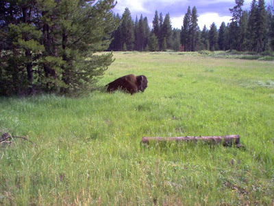
Acoustic Atlas is a Montana State University Library project that features an ArcGIS Storymap. The Acoustic Atlas storymap is an audio and visual tour of Montana’s four ecosystems. As you scroll through Acoustic Atlas you will see read text and see pictures of the four ecosystems. While scrolling you will also hear the sounds of birds, […]
Five Digital Mapping Tools That Aren’t Made by Google

Google Earth and Google’s My Maps are great tools for students to use to create multimedia maps. But Google isn’t the only game in town when it comes to digital map creation tools. In fact, there are some good ones that are freely available to you and your students outside of what Google offers. Here’s […]
The Living Atlas of the World

The ArcGIS Living Atlas of the World is a collection of thousands of online, interactive maps representing all kinds of data. The contents of the collection range from relatively simple displays of historical map imagery to complex, displays of data updated nearly live. For example, this map displays active hurricanes, cyclones, and typhoons. Another good […]
Acoustic Atlas – Sounds of the Wild West
Acoustic Atlas is a Montana State University Library project that features an ArcGIS Storymap. The Acoustic Atlas storymap is an audio and visual tour of Montana’s four ecosystems. As you scroll through Acoustic Atlas you will see read text and see pictures of the four ecosystems. While scrolling you will also hear the sounds of birds, […]
The Globe of Extremes – An Interactive Map
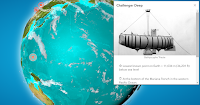
The Globe of Extremes is an interesting interactive map of the extremes of the Earth. On the map you’ll find things like the deepest spot on Earth, the point furthest from any ocean, and the highest permanent settlement in the world. When you open The Globe of Extremes it immediately starts to slowly spin to […]