How to Share Google Street View Imagery Including Building Interiors
It’s no secret to those of you who have followed my blog for long, I love exploring in Google Maps, Earth, and Street View. I can spend hours just lucky dipping around the world. When I was a kid I enjoyed looking at maps in school. I’m sure that if Google Street View existed when […]
Worldle Daily – A Street View Game

The Wordle craze seems to have settled down a bit since its height earlier this year (or at least fewer people are sharing their scores on social media). That hasn’t stopped developers from creating many variations on the game. One such variation that I recently tried is Worldle Daily. Worldle Daily is a combination of […]
Google Publishes 15 Favorite Street View Images
Google Maps turned 15 today. To celebrate, Paddy Flynn (Vice President of Geo Data Operations at Google), published Street View’s 15 Favorite Street Views. Notably, only one of the fifteen actually has a street in it! The rest are images of interesting places around the world and one is from space. My favorite of the […]
Polar Bear “Street” View Lesson Plans

Polar Bears International offers a set of extensive lesson plans designed to help students learn about polar bears and their habitat. One of those lesson plans is called Street View and Polar Bears. In Street View and Polar Bears students use Google Maps to explore the geography, geology, and ecosystem of the tundra around Churchill, Manitoba, Canada. […]
Mapping Local Art – A Google Maps and Earth Activity

Winslow Homer [Public domain] via Wikimedia Commons. Whenever I conduct workshops on Google Maps and Google Earth I always point out that there are uses for those tools beyond the realm of geography and history. A recent, popular, example of this is found in the Google Arts & Culture Institute’s Street View imagery of museums. While the Google […]
Two Free Apps for Capturing Immersive Imagery

In 5 Good Resources for Teaching and Learning About World War II I mentioned that I captured some photospheres at the WWII Museum in New Orleans. I created those photospheres for use in virtual reality viewers. The tools that I used for creating those photospheres were the Google Cardboard Camera app and the Google Street […]
Take a Look at the Iditarod in Street View
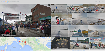
When the annual Iditarod sled dog race started in Alaska last weekend I shared a few resources for learning about the race and the dogs. Another way to learn a bit about the race and about Alaska is to view parts of the race in Google Street View. The imagery takes viewers from the start […]
Three Geography Games Based on Google Maps and Google Earth
One of the things that I emphasize to students before they embark on any kind of research or problem-solving task is to take a good long look at the information that they already have before them. To that end, I’ll often request that they construct a list of what they know about a topic or […]