
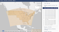
A Good Tool for Mapping Census Data
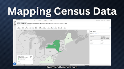
Earlier today I was looking for a dataset that I could use in a new data visualization tool that I’m testing out. That quest took to me the website of the U.S. Census Bureau. It was there that I went down a rabbit hole of looking at data. Eventually, I stumbled into a mapping tool […]
How to Install Google Earth Pro on a Mac

A few weeks ago I shared directions for adding Google Drive videos to Google Earth tours. The demonstration that I gave was done with Google Earth Pro on my Mac. That demo prompted an email from a viewer who needed some help installing Google Earth Pro on her Mac. To answer that email I made […]
Turn Pictures Into Digital Map Pins
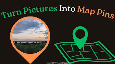
Felt.com is a digital mapping tool that launched late last year and has since impressed me with both its ease of use and its plentiful features. The latest feature added to Felt that I really like is the option to take any of your pictures and use them as placemarkers or pins on your maps. […]
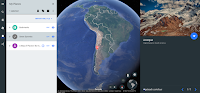
Felt – A New Way to Create Multimedia Maps

About a week ago Larry Ferlazzo mentioned a new mapping tool in one of his blog posts. That tool is called Felt. I tried it a few days ago and I have to say that I like it a lot. Felt offers a lot of easy-to-use tools for creating custom maps. Some of the features […]
Five Google Earth Activities to Get Kids Interested in the Outdoors

In last week’s Week in Review I mentioned a new book titled Outdoor Kids in an Inside World. In the book Steven Rinella presents a lot of ideas for getting kids interested and involved in learning about nature. In the first chapter he presents a big list of ideas for things that you can do […]
Three Great Google Maps Features for Teachers

Google Maps is one of my favorite tools to use in history and geography lessons. I’ve been using it for at least as long as I’ve been writing this blog (15 years). Like all Google products it has evolved over time and some features have gone away while others have been added. And there are […]
12 Fun, Challenging, and Interesting Geography Games for Students

Last year I published a list of geography games for students. Since then I’ve come across a few more interesting geography games and one that I used for years has disappeared. Here’s my updated list of fun, challenging, and interesting geography games for students. Map Quiz is exactly what its name implies. It’s a quiz game […]
Some of my Favorites – Historic Maps in Google Earth

This week is school vacation week here in Maine. I usually take this week off to go ice fishing on Moosehead Lake. Unfortunately, that’s not happening this year. Instead I’ll be “staycationing” and working on some projects around home. While on my staycation I’ll be sharing some of my personal favorite tools and blog posts. […]
Gribrouillon – Freehand Drawing on Online Maps

For many years I’ve recommended Scribble Maps as a no-account-required alternative to Google’s My Maps. Scribble Maps lets create freehand drawings on digital maps. Today, thanks to Maps Mania, I learned about another tool for making freehand drawings on digital maps. That tool is called Gribroullion. Using Gribroullion is a straight-forward process. Simply go to […]
Google Earth Now Works in Firefox, Edge, & Opera!

I shared this news in my podcast earlier today, but just in case my podcast isn’t the first thing you listen to in the morning, I’m excited about the web version of Google Earth finally being available in Firefox, Edge, and Opera. The Tech Lead Manager and a software engineer for the Google Earth announced […]
How to Create a Map-based Story With StoryMap JS
StoryMap JS is a free tool that comes from the same people that offer the popular multimedia timeline tool called Timeline JS. On StoryMap JS you can create map-based stories. You create the story by matching slides to locations on a map. In the following video I demonstrate how to use StoryMap JS. Applications for […]
The Web Version of Google Earth Finally Gets a Measuring Tool

Distance measurement has been a feature of the desktop version of Google Earth for as long as I have been using it. So I was surprised when it wasn’t included in the browser-based version of Google Earth that was launched last year. This morning Google announced that a measuring tool has finally been added into […]
An Updated Version of Google Earth Released

Thanks to the Google Earth Blog I just learned about the release of an updated version of Google Earth Pro. Google Earth Pro (it’s free despite the “pro” designation) is the desktop version or “classic” version of Google Earth. The latest version includes thirteen improvements to Google Earth Pro. You can see the full list […]
Three Sites That Help Students Compare the Size of Countries and States
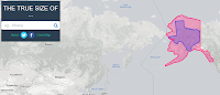
Over the weekend Open Culture featured one of my favorite websites to use in geography classes. That website is called The True Size Of… and it lets you quickly compare the size of two countries or two states within the United States. To compare two countries simply enter one into the search box then enter a […]
Explore Street View Imagery With Your Voice
This afternoon at the Practical Ed Tech Chromebook Camp we spent some time exploring and talking about ways that Google Maps, Street View, Google Earth, and virtual reality can be used in classrooms. One of the things that seemed to engage everyone was Speak To Go With Google. Speak to Go is a Google WebVR […]
A Comparison of Historic Journeys
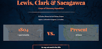
I’m writing this as I zoom through the air at 500+ miles per hour to get home after ISTE 17. Just 100 years ago this trip would have been on a train for days. And 100 years before that the journey would have be counted in weeks and months. That kind of comparison is what […]
GE Teach Tour Builder – Create Google Earth Tours for the Web
GE Teach is a fantastic project developed by Josh Williams. Josh and his students were some of the first to use the new version of Google Earth in a classroom. In fact they used it before it was available to the public. (Click here for a video overview of the new Google Earth). The new […]
Peaks and Valleys – An Interactive Story Map
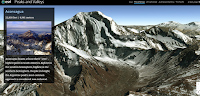
Peaks and Valleys is an interactive story map produced on the ESRI platform. As you scroll through the story map the highest peaks and lowest valleys on each continent are revealed in 3D renderings. As you scroll through the 3D imagery a sidebar pops-up. That sidebar contains a photograph of the peak or valley and […]
Take a Virtual Tour of Petra In Google Cardboard or In Street View

Last year Google added a virtual tour of Petra to its collection of landmarks that you can see in-depth in Google Maps Street View. This week that tour was updated for viewing in Google Cardboard VR headsets. Much of the imagery used in the tour was captured by a Street View Trekker camera. Take a […]
Two Good Sets of Animated Maps for U.S. History Students
Creating my earlier post about resources for learning about Pearl Harbor prompted me to revisit a couple of animated maps of U.S. History. History Animated is a resource that I first started using with students in 2009. History Animated provides animations of battles of the American Revolution, the War of 1812, the US Civil War, and US Campaign in […]
Use Google Earth to Create Narrated Tours of Mars & the Moon
Last night I published a video about how to make simple Google Earth tours. This morning I was greeted by an email in which a reader asked me if it was possible to create tours of Mars by using Google Earth. The answer to that question is yes. You can use Google Earth to create […]
5 Fun Geography Games for Geography Awareness Week
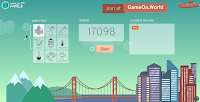
On each of the previous three days I’ve shared some resources and ideas for Geography Awareness Week. Continuing that pattern, here are five fun games that your students can play to test and develop their knowledge of geography. GameOn World is a multiplayer geography game developed by a high school teacher and his student in Portland, […]
11 Video Tutorials About Creating Multimedia Maps
Next week is Geography Awareness Week. That is a great time to have your students create their own multimedia maps. Yesterday, I shared five map creation activities that your students can do to increase their understanding of geography. In that post I suggested using Google’s My Maps, Scribble Maps, and National Geographic’s Map Maker Interactive […]
5 Map Creation Activities for Geography Awareness Week
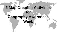
Next week is Geography Awareness Week. As a social studies teacher I think every week should be Geography Awareness Week, but I digress. Looking at maps is fine, making maps is better. Here are five map creation activities that your students can do to increase their understanding of geography. 1. Create a map of a […]
An Easy Way to Find Google Earth Tours
In my presentation To Geography & Beyond With Google Maps & Earth I always share some tips on how to locate Google Earth tours. One of those tips is to refine your Google search by file type and select .KMZ. In the video embedded below I provide a demonstration of how to quickly find, open, […]
PAT – Free, Open Source, Portable Atlas

PAT is a free collection of maps developed by Ian Macky. The collection includes maps of every country in the world.The collection also includes maps of U.S. states, maps of Canadian provinces, Australian states, and regional maps. You can download any and all of these detailed maps for free. Applications for Education PAT is an excellent resource for geography and […]
Mission Mapquest – Create a Map Game That Can Be Played on iPads

Mission MapQuest is a great map game creation tool developed by friend Russel Tarr for his ClassTools.net website. The concept behind Mission Mapquest is rather straight-forward one. On Mission Mapquest you create a series of clues that your students need to follow to identify places around the world. You can add as few or as many clues to your MapQuest […]
Three Ways for Students to Compare the Sizes of Countries and States
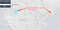
My students here in Maine always think of our state as being a big place and it is relative to the rest of New England. Compared to our friends in the west, Maine is a small place. Similarly, they sometimes have trouble understanding the size of the lower 48 states compared to Canada. The following […]