How to Make Multimedia Maps on Padlet

Geography Awareness Week is coming up in a couple of weeks. In preparation for my favorite academic week of the year, I’ve recorded an updated tutorial on how to make multimedia maps with Padlet. Padlet is one of the most versatile tools you can put in your digital toolbox. Creating multimedia maps is just one of […]
Five Tools for Telling Stories With Maps

One of my favorite alternatives to traditional book report assignments is having students create multimedia maps based on books they’ve read. Google Lit Trips first made that idea popular more than a decade ago. Of course, creating a multimedia map is also an excellent way for students to summarize and geo-locate a series of related […]
Collaboratively Create Maps on Padlet

Padlet has been in my list of top collaboration tools for nearly a decade. I started using it with my students back when it was still known as Wallwisher. There are many ways to use Padlet from simply providing a place to share text notes to using it as a place to collect video samples […]
Three Tools for Creating Custom Maps Without a Google Account

Google’s My Maps is a great tool for designing custom maps. The problem with it is that students can only save their work if they have Google accounts. If your school uses G Suite for Education that’s probably not a problem, but it is a problem for students who don’t have G Suite accounts. If […]
Map-based Stories from National Geographic
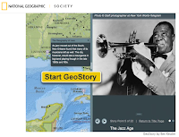
GeoStories are short, map-based stories featured on National Geographic Education. The stories combine text, maps, and pictures to tell a story as a series of slides connected to placemarks on maps. National Geographic Education currently offers twenty-three GeoStories. The current GeoStories cover subjects in the areas of politics, ecology, music, and exploration. Applications for Education Even […]
Great Journeys and Explorations – Stories Told With Interactive Maps and Timelines

Ever since I was an elementary school student I have loved reading about great journeys and explorations like those of Lewis and Clark, James Cook, and Robert Peary. As an adult I still love those stories and recently started reading The River of Doubt for a second time. Picking up that book reminded me of […]
An Animated Map of the Rise and Fall of Communism

The Spread of Communism is an animated map that shows the rise and fall of communism from 1917 through 2017. When you visit the map you can press the play button in the lower, right corner to play the animation. When it plays the animation highlights each country according to the year in which a […]
Storymap JS – Tell Stories With Maps

The New York Times has a new feature called Harriet Tubman’s Path to Freedom. The feature is a presented in scrolling map format. The map is combined with a timeline format that shows the sequence of and locations of significant moments of Tubman’s work in freeing herself and helping other slaves escape. Harriet Tubman’s Path […]
11 Video Tutorials About Creating Multimedia Maps
Next week is Geography Awareness Week. That is a great time to have your students create their own multimedia maps. Yesterday, I shared five map creation activities that your students can do to increase their understanding of geography. In that post I suggested using Google’s My Maps, Scribble Maps, and National Geographic’s Map Maker Interactive […]
How to Create a Map and Timeline Mashup

myHistro is a free multimedia timeline creation tool. When you create a timeline on myHistro each event that you add can be simultaneously displayed on a map on the same screen. Every event that you add to your myHistro timelines can include pictures and videos. On myHistro you can build a personal timeline or build […]