How to Create a Story Map

A couple of days ago I published a post about a story map titled 1,001 Novels: A Library of America. That post is already one of the most popular things I’ve published this year! Viewing 1,001 Novels: A Library of America reminded me of a free tool that students can use to create story maps. […]
Five Digital Mapping Tools That Aren’t Made by Google

Google Earth and Google’s My Maps are great tools for students to use to create multimedia maps. But Google isn’t the only game in town when it comes to digital map creation tools. In fact, there are some good ones that are freely available to you and your students outside of what Google offers. Here’s […]
How to Create a Story Map

StoryMap JS is a tool that I’ve been using and recommending for many years. It’s a free tool that students can use to create a story map in a manner similar to Google’s My Maps or the old Google Tour Builder. The difference between those tools and StoryMap JS is that StoryMap JS is much […]
5 Ways to Tell Stories With Maps
Maps can be great tools for supporting nonfiction and fiction stories. Being able to see the greater context of a location can go a long way toward helping students see the complete overview of a story. This can be helpful for learning about historical events, for supporting biographies, or for seeing the settings of fiction […]
Peaks and Valleys – An Interactive Story Map
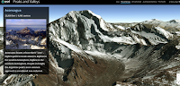
Peaks and Valleys is an interactive story map produced on the ESRI platform. As you scroll through the story map the highest peaks and lowest valleys on each continent are revealed in 3D renderings. As you scroll through the 3D imagery a sidebar pops-up. That sidebar contains a photograph of the peak or valley and […]