
GeoGeek AR – An Augmented Reality Geography Game
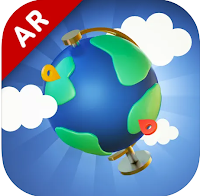
GeoGeek AR is a fun app for testing and developing your knowledge of world geography. As its name and icon imply, the app uses augmented reality to put a virtual globe in any space that you choose. You can spin the globe with your fingers or simply move around the room to see different parts […]
City Guesser 2.0 – Guess City Locations from Video Clips

For years City Guesser has been a popular geography game in which players have to guess the identity and location of a city based on Google Street View imagery. The new version of City Guesser replaces Google Street View imagery with street level video clips. In City Guesser 2.0 players are shown video clips (silent […]
50 Years of Migration Waves

This morning while reading a National Geographic article about animal migrations in national parks I stumbled onto a related feature titled Migration Waves. Migration Waves is a series of graphs depicted the movement of humans between countries between the years 1967 and 2017. The graphs on Migration Waves are grouped according to four factors that […]
Free Wall Maps for Your Classroom
Like good manners and flannel shirts, wall maps never go out of style. If you need some new maps to put on the walls of your classroom, take a look at the free maps that National Geographic offers. Nat Geo Map Maker kits provide teachers with files for printing wall maps, table top maps, and […]
51 World Geography Games for Kids
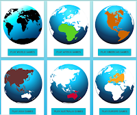
World Geography Games is a free site that features 51 geography games. The games are simple identification games in which students are shown the name of a country, state, city, or geographic feature and then have to click on the correct locations. Students earn points for each correct answer. World Geography Games tracks how many attempts […]
Peaks and Valleys – An Interactive Story Map
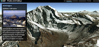
Peaks and Valleys is an interactive story map produced on the ESRI platform. As you scroll through the story map the highest peaks and lowest valleys on each continent are revealed in 3D renderings. As you scroll through the 3D imagery a sidebar pops-up. That sidebar contains a photograph of the peak or valley and […]