Five Concepts You Can Teach Through Geocaching

Geocaching is one of the things that I spend a good bit of time talking about in both my workshop and in my webinar about blending technology into outdoor learning. Geocaching is a great activity to do to get kids outside for hands-on learning experiences. Here are five things that you can teach through geocaching […]
Create Your Own USGS Maps

Earlier this year I highlighted the galleries of free to use and re-use media that the USGS hosts. Earlier this week I was back on the USGS site looking in those galleries when I noticed something new to me. That something is the USGS National Map Viewer. Don’t the name fool you, the USGS National […]
Yellowstone Distance Learning Opportunities

A couple of weeks ago I shared some information about Denali’s Distance Learning Program for K-12 classrooms. This week I learned that Yellowstone National Park offers a similar program. Yellowstone National Park’s distance learning program lets you schedule a twenty to forty minute virtual presentation with a Yellowstone Park ranger. Presentations can be scheduled for […]
The USGS Multimedia Gallery Offers Excellent Public Domain Images and Videos
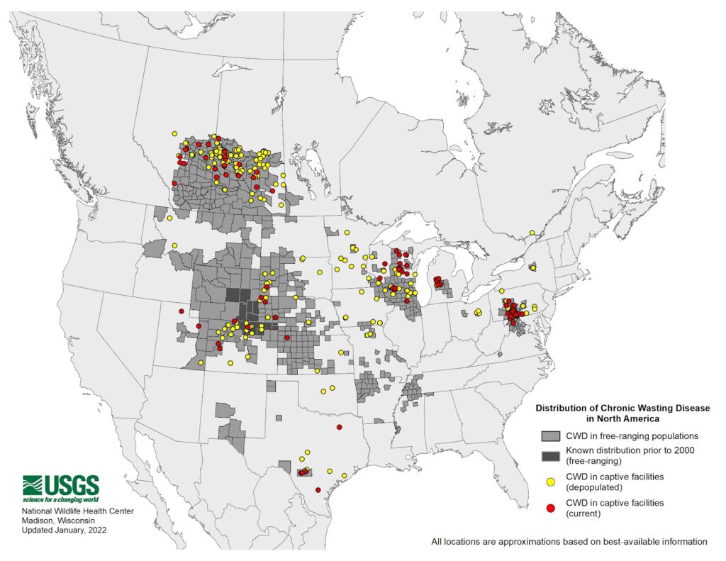
The USGS Multimedia Gallery contains large collections of educational videos, animations, audio recordings, pictures, and slideshows. As you might expect, you’ll also find lots of maps in the USGS multimedia gallery. You can browse and search the gallery according to media type, year of publication, and keyword. In addition to the videos in the USGS Multimedia Gallery you can […]
These Geosciences Lessons Rock

K-5 GeoSource is a great resource produced by the American Geosciences Institute. On K-5 GeoSource you will find free lesson plans, science fair project ideas, links to virtual activities, and resources for professional development. The first time I looked at the site back in 2009 it had a distinct Web 1.0 feel. The site has improved of late to […]
Running Free Rivers

River Runner is a neat website that shows you how a drop of water travels from anywhere in the United States to the Atlantic Ocean, the Pacific Ocean, or the Gulf of Mexico. To use River Runner simply go to the site and click on any location in the United States. As soon as you […]
The Growth of Mount Everest – A Math and Geology Lesson

Mount Everest is nearly a meter taller than it was a day ago. No, it didn’t actually grow a meter overnight. China and Nepal have agreed on a new measurement for the height of Mount Everest. There are at least two lessons that can be developed out of this news. One of the reasons for […]
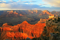
Ten Resources for Learning About U.S. National Parks

Last week TED-Ed published a new lesson about national parks. The lesson explains the origins of the U.S. National Parks system and concludes with explanations of the challenges facing national parks managers around the world. The lesson also explains how parks managers try to balance access and conservation while also respecting the rights of indigenous […]
USGS Find a Feature Challenges – Outdoor Learning Opportunities

Last week I wrote about the Learning from Home resources available from the USGS. While it’s not specifically a part of the Learning from Home resources, USGS offers another selection of activities that can be used for “at home” learning. Those activities are called Find a Feature. The USGS Find a Feature challenge is a […]
USGS Offers Online and Hands-on Learning from Home Resources
Since I was in elementary school I have enjoyed looking at maps and day dreaming about the places those maps depict. I like maps so much I have a couple of USGS topographical maps on the wall in my office. So whenever the USGS emails me with something new, I immediately investigate it. The latest […]
Deserts 101 – A Nice Nat Geo Lesson

National Geographic offers a good series of more than one hundred YouTube videos designed to provide viewers with concise explanations of the big concepts of a variety of topics in science. The series includes videos about volcanoes, plastics creation and recycling, the solar system, and invasive species. The latest video added to the National Geographic […]
Elementary School Rocks
K-5 GeoSource is a great resource produced by the American Geosciences Institute. On K-5 GeoSource you will find free lesson plans, science fair project ideas, links to virtual activities, and resources for professional development. The first time I looked at the site back in 2009 it had a distinct Web 1.0 feel. The site has improved of late to […]
The Myth of the Giant’s Causeway Explained

The Giant’s Causeway is one of the UNESCO World Heritage Sites that I have had the privilege to see in person. It can be seen in Google Maps Street View too. It’s a unique geological site created by molten basalt. That’s interesting but not as interesting as the myth of its creation. The myth of […]
Making North America – Interactive Map Quiz

Making North America is a NOVA production that chronicles the geological formation of North America. You can watch the series online to learn about the natural forces that shaped the landscape of North America. As a complementary resource for classrooms, NOVA offers an interactive map that features unique geological features of North America. Making North […]
How Do Glaciers Move?
Five years ago my old pal Morrison (RIP) and I traveled down the Columbia Icefields Parkway. It was a great way to experience part of the Canadian Rockies including seeing the glaciers that melt and feed tributaries of rivers that will eventually reach the Pacific, Atlantic, and Arctic oceans. That begged the questions of how […]
A Great Example of Using Google Maps in Science
At almost every conference that I attend I offer a session about Google Maps and Google Earth. Most of the people that come to those sessions are social studies teachers. That is because there is a natural connection between maps and topics in social studies. But there are plenty of other subject areas and topics […]
Use Google Maps to Tell a Story Within a Story
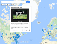
Google’s My Maps platform lets anyone who has a Google Account create their own multimedia maps. One of my favorite features within the My Maps platform is the option to create a slideshow of images and videos within a placemark. By using that feature you can tell a story within a story. In My Maps […]
A Short Lesson About the Great Lakes
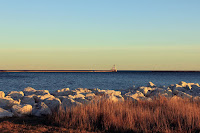
In the fall of 2012 I crisscrossed my way across Michigan’s upper peninsula. In doing so I was able to experience some of the magnitude of Lake Superior, Lake Michigan, and Lake Huron. I was along the shore of Lake Superior during a storm that created waves the size of those we see on Maine’s […]
GPlates Portal – Visualizations of Geophysical and Geological Data
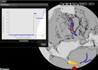
GPlates Portal is a resource that teachers of geology and geography will want to spend some time exploring. GPlates Portal is produced by the School of Geosciences at the University of Sydney. In the GPlates Portal you will find twelve interactive displays of geological and geophysical data. Most of the interactive displays that you will […]
How Does a Canyon Become Grand? – And Other Lessons on the Shaping of North America
Earlier this month TED-Ed published a new lesson about how the physical geography of North America has changed over time. The lesson, titled How North America Got Its Shape, includes brief explanations of the roles of shifting tectonic plates, erosion, and volcanic activity in shaping North America. The lesson includes the Grand Canyon as an […]
A Tour of the Geology of U.S. National Parks
This evening while picking up pizza for dinner I ran into one of my old assistant principals who told me about the road trip that he just completed with his family. They went on a tour of national parks in Arizona, New Mexico, Nevada, Wyoming, and Montana. Listening to him reminded me of a nice […]
Neat Resources for Learning About Yellowstone
This month’s issue of National Geographic Magazine is all about Yellowstone National Park. The magazine’s website has some excellent articles, videos, and interactive graphics about the animals and geology of the park. Unfortunately, about half of the resources on National Geographic Magazine’s website are restricted to people who have paid for a subscription to the […]
Another Great Resource for Learning About Mount Everest
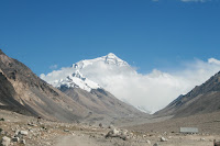
On Wednesday I shared my list of resources for teaching and learning about Mount Everest. This afternoon, thanks to Larry Ferlazzo, I learned about another good resource for learning about Mount Everest. Why is Mount Everest so Tall? is a new TED-Ed lesson in which students learn why the peak of Everest is so high, […]
Exploring Mount Everest – Street View and More
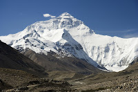
The spring climbing season on Mount Everest and the surrounding peaks of the Himalaya is now upon us. As long-time readers of this blog may recall, one of my bucket list items is seeing Mount Everest in person. Until then I have to entertain myself with books, videos, and imagery of the mountain. Here are […]
Elementary School Lessons About Fossils and Rocks
The American Geosciences Institute produces K-5 GeoSource which is a site that hosts lesson plans and other educational resources for teachers. K-5 GeoSource has a very Web 1.0 look to it, but if you do a little digging you’ll find some helpful materials. A few of the resources that I looked at were this free […]