How to Share Google Street View Imagery Including Building Interiors
It’s no secret to those of you who have followed my blog for long, I love exploring in Google Maps, Earth, and Street View. I can spend hours just lucky dipping around the world. When I was a kid I enjoyed looking at maps in school. I’m sure that if Google Street View existed when […]
Three Good Ways to Map Spreadsheet Data
In my previous post about how to create a story map I featured a tool called StoryMap JS. That tool is great for making story maps that have no more than about twenty scenes. Any more than that and the process becomes a bit cumbersome and tedious. Fortunately, there are tools that you can use […]
Turn Pictures Into Digital Map Pins
Felt.com is a digital mapping tool that launched late last year and has since impressed me with both its ease of use and its plentiful features. The latest feature added to Felt that I really like is the option to take any of your pictures and use them as placemarkers or pins on your maps. […]
A World of Musical Explorers
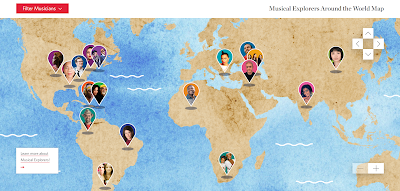
I wrote about this neat resource a couple of years ago. A recent post on the Maps Mania blog prompted me to revisit it. Carnegie Hall hosts some excellent online instructional resources for music teachers. One of those resources is called Musical Explorers Around the World. Musical Explorers Around the World is an interactive map […]
48 Digital Mapping Tutorials
Even though I write a lot about Google Earth and Google Maps, there is more to digital mapping than just using those tools. In fact, there are some great digital mapping tools not made by Google that students can use to create things like historic map overlays, map and timeline combinations, and map-based stories. In […]
GE Teach – Make Side-by-Side Map Comparisons in One Browser Tab
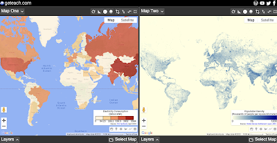
GE Teach is a great map tool that is developed and maintained by a high school teacher in Texas named Josh Williams. GE Teach has gone through a bunch of iterations over the years and the latest version is better than ever. On GE Teach students can compare two maps side-by-side. Students can select from gallery […]
Create Historic Map Overlays With These Free Tools
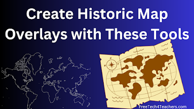
Yesterday morning I shared a collection of more than 100,000 historic maps for classroom use. In that post I mentioned using those maps to create digital overlays on current maps. Google Earth provides a couple of ways to do that. Felt.com is another digital mapping tool that can be used for the same purpose. In […]
45 Digital Mapping Tutorials

This month I’ve been spending some time organizing the tutorial videos on my YouTube channel. To that end I’m creating playlists that are organized thematically. The latest playlist that I’ve created is titled Digital Mapping. The playlist currently contains 45 tutorial videos covering more than just Google Maps. In the playlist you’ll find tutorials on […]
How to Create Map Overlays
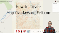
Felt was one of my favorite new tools in 2022. In fact, I liked it so much that I included it in my Best of the Web for 2022. Felt is a free multimedia mapping tool that I think is easier for first-time users to use than Google’s My Maps or ESRI’s mapping tools. Right […]
New Base Map Options on Felt

Felt is a new digital mapping tool that I’ve featured a few times in the last month because I think it is fantastic alternative to Google’s My Maps and the web version of Google Earth for creating custom maps. In fact, I like it so much that I demonstrated it in my Best of the […]
Two Cool Mapping Tools in the Felt Mapping Platform

A couple of weeks ago I published an introductory overview of a new digital mapping platform called Felt. As I said in that introduction, I’ve only begun to scratch the surface of all of the things that students can do and make on Felt. One of those things is the ability to quickly and easily […]
Five Digital Mapping Tools That Aren’t Made by Google

Google Earth and Google’s My Maps are great tools for students to use to create multimedia maps. But Google isn’t the only game in town when it comes to digital map creation tools. In fact, there are some good ones that are freely available to you and your students outside of what Google offers. Here’s […]
How to Create a Story Map

StoryMap JS is a tool that I’ve been using and recommending for many years. It’s a free tool that students can use to create a story map in a manner similar to Google’s My Maps or the old Google Tour Builder. The difference between those tools and StoryMap JS is that StoryMap JS is much […]
How to Make Multimedia Maps on Padlet

Geography Awareness Week is coming up in a couple of weeks. In preparation for my favorite academic week of the year, I’ve recorded an updated tutorial on how to make multimedia maps with Padlet. Padlet is one of the most versatile tools you can put in your digital toolbox. Creating multimedia maps is just one of […]
How to Create a Digital Map Collection in Wakelet

Wakelet is a free, collaborative bookmarking and file organization tool that puts things into a nice visual display. So when a former colleague emailed me a couple of days ago to ask for help creating a collection of digital maps Wakelet was one of the first tools to come to mind (Padlet was the other). […]
A Good Place to Find Old Maps Online

Old Maps Online is an online map that you can browse and search to find historical maps to view online, to download, and to print. You can search the map by entering a location or you can just pan and zoom around the world to find historical maps. In the video embedded below I demonstrate […]
Finding a Geographic Opposite

One evening last week my daughters were playing with the globe pillow that is featured in this blog post. They started asking questions about what each place is called and where it is relative to where we live. Answering their questions reminded me of the concept of an earth sandwich. The idea of an earth […]
Create Animated Maps on Mult Dev – One of My New Favorites in 2021

I’m taking this week to recharge and get ready for the next session of the Practical Ed Tech Virtual Summer Camp. For the next few days I’m going to highlight some of my favorite new and new-to-me tools so far this year. Mult Dev is a free tool that lets you quickly create animated maps. In the time […]
Three Good Options for Drawing on Digital Maps

Creating layers and tours in Google Earth and Google My Maps can be a great way for students to assemble collections of geolocated information to summarize research, create a book tour, or even develop safe walking and biking routes. But sometimes you just need to quickly draw or pin things to a digital map. In […]
Story Spheres – Create Immersive Audio Tours of Interesting Places

Story Spheres is a neat tool for adding audio recordings to 360 imagery. Story Spheres lets you upload short audio recordings in which you describe to viewers what they’re seeing, the history of what they’re seeing, and the significance of what’s in the scene they’re seeing. It’s possible to upload multiple recordings. When you’re done […]
5 Digital Mapping Activities

On Monday I shared a couple of tutorials about measuring distances in Google Maps and Bing Maps. Yesterday, I shared a few resources for helping students understand map projections. This morning, I have some more tutorial videos that might help or inspire you to create digital mapping activities to use in your geography or history […]
Gribrouillon – Freehand Drawing on Online Maps

For many years I’ve recommended Scribble Maps as a no-account-required alternative to Google’s My Maps. Scribble Maps lets create freehand drawings on digital maps. Today, thanks to Maps Mania, I learned about another tool for making freehand drawings on digital maps. That tool is called Gribroullion. Using Gribroullion is a straight-forward process. Simply go to […]
How to Create Interactive Images With Classtools

A couple of days ago I wrote about a new tool from Classtools called Image Annotator. It does exactly what it says on the tin. I made the following short video to demonstrate how easy it is to use the Classtools Image Annotator. In the video I demonstrate annotating an image of a map, but […]
Collaboratively Create Maps on Padlet

Padlet has been in my list of top collaboration tools for nearly a decade. I started using it with my students back when it was still known as Wallwisher. There are many ways to use Padlet from simply providing a place to share text notes to using it as a place to collect video samples […]
The Globe of Extremes – An Interactive Map
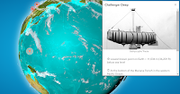
The Globe of Extremes is an interesting interactive map of the extremes of the Earth. On the map you’ll find things like the deepest spot on Earth, the point furthest from any ocean, and the highest permanent settlement in the world. When you open The Globe of Extremes it immediately starts to slowly spin to […]
8 Options for Making Digital Maps
In yesterday’s post about English Heritage’s Map of Myth, Legend, and Folklore I included a mention of using StoryMap JS to create interactive maps. That prompted a response from Cindy Rudy who suggested the idea of using Thinglink or Google Earth to make similar maps of myths, legends, and folklore. That was my inspiration for this […]
5 Ways to Tell Stories With Maps
Maps can be great tools for supporting nonfiction and fiction stories. Being able to see the greater context of a location can go a long way toward helping students see the complete overview of a story. This can be helpful for learning about historical events, for supporting biographies, or for seeing the settings of fiction […]
800+ Persuasive Maps – And a Tool for Making Your Own

About a week ago Open Culture published an article about Cornell University’s Persuasive Cartography collection. I hadn’t seen that collection before so I went down a rabbit hole looking at map after map for a good 45 minutes. Persuasive maps aren’t maps that you would use to teach a classic geography lesson. That’s because persuasive […]
Three Tools for Creating Custom Maps Without a Google Account

Google’s My Maps is a great tool for designing custom maps. The problem with it is that students can only save their work if they have Google accounts. If your school uses G Suite for Education that’s probably not a problem, but it is a problem for students who don’t have G Suite accounts. If […]