
All About Venice – Another Post Inspired by my Daughters

A few days ago while driving home from seeing a community theater’s musical production of The Little Mermaid one of my daughters asked me “why does Venice have canals instead of roads?” It was a question that I was happy to answer. The question also inspired me to revisit some items on the topic that […]
How to Use Street View Imagery in Canva Presentations
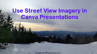
Earlier this week I published a tutorial for making your first presentation in Canva. After you and or your students feel comfortable with the basics, you may want to start exploring some of the advanced features available within Canva. One of those is the ability to embed interactive Google Maps and Google Street View imagery […]
Three Ways to Share Google Maps Views in Google Classroom

Google Maps is one of the tools that I always list as a must-have for history and geography teachers. It provides an easy way to show students multiple, detailed views of the significant natural and human-made landmarks they’re learning about in your classroom. Projecting them on a big screen in the front of your classroom […]
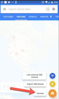
How to Use Google Maps and Street View in Canva Presentations

This blog post and video is the result of my failure to get another service, that won’t be named, to do what I hoped it would. I was trying to come up with a way for students to create online, interactive atlases. After banging my head against my keyboard for a while I finally said […]
Google Publishes 15 Favorite Street View Images
Google Maps turned 15 today. To celebrate, Paddy Flynn (Vice President of Geo Data Operations at Google), published Street View’s 15 Favorite Street Views. Notably, only one of the fifteen actually has a street in it! The rest are images of interesting places around the world and one is from space. My favorite of the […]
Google Street View App
The Google Street View app is available for both Android and iOS devices. This free app allows you to do some pretty amazing things that were not possible just a few years ago. Street View allows you to create 360 degree photos directly from your phone with no special equipment. You can choose to keep […]
Meet Pegman

Google Maps and Google Earth have a very special feature and his name is Pegman. This little guy allows us explore places around the world at Street View level. You can find him near the bottom right corner of Google Maps or in Google Earth once you select a location to explore. Pegman is yellow in […]
Explore Street View Imagery With Your Voice
This afternoon at the Practical Ed Tech Chromebook Camp we spent some time exploring and talking about ways that Google Maps, Street View, Google Earth, and virtual reality can be used in classrooms. One of the things that seemed to engage everyone was Speak To Go With Google. Speak to Go is a Google WebVR […]
Learn How Venice Works – And Take a Virtual Tour Through It

The Amazing Race is one of the few television shows that I try to catch when new episodes air. This week the show was in Venice. Watching this week’s episode of The Amazing Race in Venice reminded me of a couple of neat resources for learning about the city. Venice Backstage is a seventeen minute […]
See California’s Redwoods in Google Street View
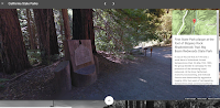
In an earlier post I shared the Google Expeditions virtual tours of national parks. Shortly after publishing that post I discovered Google’s latest additions to their Street View collections. The latest addition features Big Basin Redwoods State Park in California. This imagery lets viewers virtually experience some of the size and scale of California’s redwood […]
Virtual Reality in Education
This afternoon I joined Greg Kulowiec for a Google Hangout on Air discussion about virtual reality in education. We had a dozen or so people join us in the live chat during the Hangout. If you weren’t able to watch the live session, you can now view it as embedded below. The resources that we […]
A Simple Way to Make Your Own Google Maps Street View Game
Earlier this week I stumbled upon a local radio station’s blog in which they had posted a little game called How Well Do You Know Maine Roads? That game was nothing more than ten Google Maps Street View images that you had to try to identify. The answers to the game prompts were posted at […]
Exploring Mount Everest – Street View and More

The spring climbing season on Mount Everest and the surrounding peaks of the Himalaya is now upon us. As long-time readers of this blog may recall, one of my bucket list items is seeing Mount Everest in person. Until then I have to entertain myself with books, videos, and imagery of the mountain. Here are […]
Travel the Iditarod Race in Google Street View
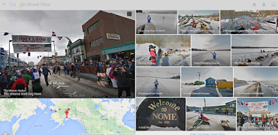
The Iditarod Sled Dog race begins today. It’s one of the events that I would love to see in person some day. While I cannot get there in person this year, I can view it in Google Street View. Earlier this week Google published a new collection of Street View imagery capture along the Iditarod […]