Learning About Languages and The Mysteries of Vernacular

Last week I wrote a blog post titled Two Lessons for a Wicked Cold Day. After publishing that post it occurred to me that readers who are not familiar with New England may be wondering why I chose the word wicked. Sure enough, someone emailed me last night to ask what I meant by “wicked […]
Tracking Santa and Programming With Santa
My kids are home from school today as this is the first day of their winter vacation. The level of anticipation for Santa’s arrival is quite high (my kids are five and six). One of the things they may do today is track Santa and play some Santa-themed games on Google’s Santa Tracker website. One […]
2022 Fall Foliage Prediction Map – And Why Leaves Change Color in the Fall

The 2022 Fall Foliage Prediction Map is a feature of the SmokyMountains.com website. The map displays a week-by-week prediction of when leaves in the continental United States will be changing colors from now through the end of November. You can see the predictions change by moving the timeline at the bottom of the map. On the same […]
NearbyWiki – A Mapped Display of Wikipedia

NearbyWiki is a new website that displays Wikipedia entries on an interactive map. The purpose of NearbyWiki is for visitors to learn about buildings, statues, and parks by clicking through a map. For example, a search for Boston on NearbyWiki will reveal more than 500 markers on the map in and around Boston. You can […]
The Geography of Baseball Fans

The Major League Baseball season started yesterday. This morning while I was flipping through some highlights of yesterday’s games, I was reminded of a neat map that I cam across a few years ago. SeatGeek’s interactive map titled Where do MLB Fans Live? is an interactive map that shows which teams are the most popular teams […]
An Interactive Map of Surnames in Ireland

Mapping the Emerald Isle: a geo-genealogy of Irish surnames is an interactive map depicting the distribution of Irish surnames across Ireland according to the 1890 census. To use the same simply select a name from a drop-down menu in the list and the map will change to show you in which counties people with that […]
Nine Interactive Maps Depicting the History of the United States

American Panorama is a great resource from the University of Richmond that I first reviewed six years ago. Since then it has expanded from four interactive maps to nine interactive maps of United States history. American Panorama aims to be an atlas of United States History. Currently, American Panorama features nine interactive maps representing elements and […]
An Interactive Land Use Map

WorldCover Viewer is a new interactive land use map produced by the European Space Agency. The map lets visitors see how land is used worldwide and in specific places. Visitors can pan and zoom to see land use for an area or use the statistics explorer tools built into the map to see land use […]
Exploring Newspapers Through Maps

When I included current events as a regular part of my social studies classes I would always show a map of where a story takes place. The following websites can provide students with a geographic connection to current and historical news stories. Newspaper Map is a neat tool for locating and reading newspapers from locations all […]
An Interactive Map of Historical Sites in Every U.S. State

The Traveling Salesman Problem is a website developed by William Cook at the University of Waterloo. The site features interactive maps that chart the short distance between a series of places. One of those maps is of all of the places in the United States National Register of Historic Places, all 49,603 of them.You can […]
Musical Explorers World Map

Carnegie Hall hosts some excellent online instructional resources for music teachers. One of those resources is called Musical Explorers Around the World. Musical Explorers Around the World is an interactive map designed to introduce students to musicians, instruments, and music from around the world. To use Musical Explorers Around the World students simply have to […]
Virtually Explore America’s Quietest Roads

America’s Quietest Roads is an interactive map created by a road traffic analytics company called Geotab. The map features the quietest state or federal highway in all fifty states. They define quietest as having the least average number of vehicles traveling the road throughout the year 2015. It’s important to point out to students that […]
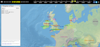
Return to Sender – Interactive Map of Postcards from WWI

Return to Sender provides an interesting way for students to find and read postcards sent to and from soldiers during World War I. Return to Sender is an interactive map on which students can see where postcards were sent in Europe during World War I. The postcards displayed through the map are part of the […]
Biomes and Ecoregions Interactive Map
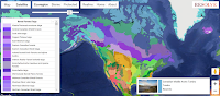
Ecoregions 2017 is an interactive map produced by Resolve for the purpose of showing the ecoregions and biomes of the world. When you visit the map you can choose to display either ecoregions or biomes. After you make that selection you can then click on any location on the map to discover the ecoregion or […]
Camera and Locomotive – A Mapped Story About the Transcontinental Railroad
Camera and Locomotive is the title of a fantastic mapped story published by the Library of Congress. Camera and Locomotive tells the story of the building of the Transcontinental Railroad and the development of photography in the United States. As you scroll through the story you will find interactive maps that are loaded with photographs […]
Lee’s Map of Gettysburg – And Tools for Making It Interactive

Today’s featured document featured by the National Archives is a copy of General Robert E. Lee’s map of the Battle of Gettysburg. If you download a copy of the map (which you can do as it is in the public domain) and then zoom-in on it, you will be able to see the notations about […]
Interactive Maps of Migrations and Changes of Seasons

Over the years I’ve featured Project Noah and the USA Phenology Network’s maps as platforms through which students can track the changes of seasons in North America. Recently, through the Maps Mania blog I learned about another good site that students can use to track the changes in seasons. That site is called Journey North. […]
An Interactive Map of English Myths and Legends

Thanks to the Maps Mania blog I just learned about English Heritage’s Map of Myth, Legend, & Folklore. The interactive map feature a couple of dozen historical sites that under the care of English Heritage. As the name of the map implies, each of the sites on the map is basis for a myth or […]
Where Do Baseball Fans Live? – Interactive Map

Despite the couple of games that the Mariners and Athletics played in Japan last week, Major League Baseball is calling today the opening day of the season. As a lifelong fan of the defending World Series champions, the Boston Red Sox, I am excited for the start of the season. Where do Red Sox fans […]
Langscape – An Interactive Map of Languages

Langscape is an interactive map created at the Maryland Language Science Center. The Langscape interactive map displays more than 6,000 markers representing more than 6,000 languages. Each marker represents the native language of that location. Zoom-in and click on a marker to learn more about the language. When you click on the marker you will […]
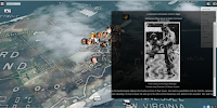
The Story of the United States Told in 141 Interactive Maps
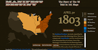
Manifest Destiny – The Story of The U.S. Told in 141 Maps is a great website developed by Michael Porath. As you probably guessed from the title of this blog post, the site features 141 interactive maps chronicling the expansion of the United States from March 1789 to August 1959. When you click on any of the […]
Interactive Map – The Battle of Gettysburg

Decisive Moments at the Battle of Gettysburg is an interactive map hosted on Smithsonian.com. The map details events of the battle and the decisions made by commanding officers on both sides of the war. You can navigate the map by using the timeline on the left-hand side of the map or by clicking the placemarks on […]
Great Journeys and Explorations – Stories Told With Interactive Maps and Timelines

Ever since I was an elementary school student I have loved reading about great journeys and explorations like those of Lewis and Clark, James Cook, and Robert Peary. As an adult I still love those stories and recently started reading The River of Doubt for a second time. Picking up that book reminded me of […]
Making North America – Interactive Map Quiz

Making North America is a NOVA production that chronicles the geological formation of North America. You can watch the series online to learn about the natural forces that shaped the landscape of North America. As a complementary resource for classrooms, NOVA offers an interactive map that features unique geological features of North America. Making North […]
Three Sites That Help Students Compare the Size of Countries and States
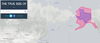
Over the weekend Open Culture featured one of my favorite websites to use in geography classes. That website is called The True Size Of… and it lets you quickly compare the size of two countries or two states within the United States. To compare two countries simply enter one into the search box then enter a […]
The Sounds of Nature Around the World
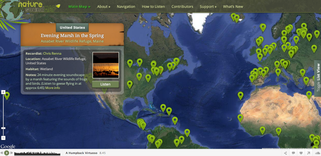
Nature Sound Map provides a wonderful way to explore the soundscape of the natural world. On the Nature Sound Map you will find placemarks containing recordings of nature. The recordings have been added to the project by professional sound recordists. Some of the recordings you will find feature the sounds of just one animal, the […]
An Interactive Display of the Declaration of Independence

The Digital Declaration of Independence is a fantastic website on which students can learn about the Declaration of Independence and the men who signed it. The Digital Declaration of Independence is an interactive display of John Trumbull’s painting Declaration of Independence, a scan of the text of the Declaration of Independence, and a map of […]
The Evolution and Disappearance of Languages
Last week I shared an interactive map of languages. That map is crowd-sourced and unfiltered which is why I recommended only using it to find recordings that you play for your students rather than letting them browse the map on their own. For interactive maps of languages spoken around the world, take a look at […]
An Interactive Map of Pearl Harbor Survivor Stories
Tomorrow marks the 75th anniversary of the Japanese attack on Pearl Harbor. Earlier this week I shared some resources for teaching and learning about Pearl Harbor. This afternoon through the Maps Mania blog I learned about another resource to add to that list. The 1941 Project is an interactive map of Pearl Harbor. The map […]
GPlates Portal – Visualizations of Geophysical and Geological Data
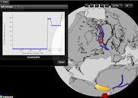
GPlates Portal is a resource that teachers of geology and geography will want to spend some time exploring. GPlates Portal is produced by the School of Geosciences at the University of Sydney. In the GPlates Portal you will find twelve interactive displays of geological and geophysical data. Most of the interactive displays that you will […]
Let the Games Begin – An Interactive Map of Issues Surrounding the Olympic Games

The 2016 Summer Olympic Games begin at the end of this week. The lead-up to the games has been full of new stories about physical, political, and economic conditions in Brazil. ESRI has published an interactive storymap about all of these issues. On Ready or Not, Let the Games Begin you can scroll through a […]
Running Reality – Mapping the Rise and Fall of Nations
Running Reality is an ambitious project that is attempting to build an interactive map and timeline of the rise and fall of nations throughout history. Currently, you can visit Running Reality and choose a date or range of dates on the timeline to see a map of nations around the world at that time. Alternatively, […]
An Interactive Cartogram of News
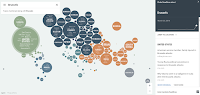
Unfiltered News is a new site that uses an interactive cartogram to help you find trending news stories from around the world. To find stories through Unfiltered News simply open the website and click on a topic listed within one of the circles on the map. Once you’ve made a selection a list of stories […]