Digital Collections of 20th Century World History Declassified
The Wilson Center Digital Archive offers many collections of declassified historical documents. The documents contain memos and transcripts of communications between diplomats and country leaders. The collections are arranged into topics and themes. You’ll find collections of documents related to the construction of the Berlin Wall, the origins of the Cold War, Sino-Soviet relations, and diplomatic efforts […]
More Than 100,000 Historic Maps for Classroom Use
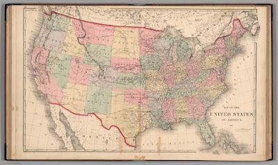
Credit: David Rumsey Map Collection, David Rumsey Map Center, Stanford Libraries. Source 1. Source 2. In this week’s Practical Ed Tech Newsletter I mentioned that digital mapping tools is one of the areas of educational technology that I’m still passionate about after sixteen years and 17,000 blog posts. And making comparisons through the use of […]
All About Explorers – It’s Still a Great Site
All About Explorers is a site that Russel Tarr told me about many years ago. I was recently going through my archives to remove links to sites that no longer exist when I came across All About Explorers again. I was pleased to see that it’s still going. All About Explorers developed by Gerald Aungst and […]
Short Lessons on Rome and Life as a Roman Teenager

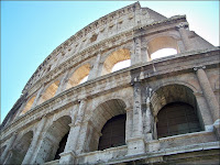
National Geographic has a great series of YouTube videos called National Geographic 101 which include videos like Ancient Rome 101. The video provides an excellent introduction to the origin, rise, and fall of the Roman Empire. The length and substance of the video makes it an ideal candidate for inclusion in an EDpuzzle lesson. TED-Ed has […]
A Small Collection of Resources for Teaching and Learning About Veterans Day

This Friday is Veterans Day. If you find yourself looking for some quick lessons to review with your students, here’s a small collection for you. ReadWorks ReadWorks is one of my favorite places to go when I need information texts about a holiday to share with students. ReadWorks has a good collection of Veterans Day articles that […]
GeoQuiz History Edition – A Fun and Challenging Geography Game

The start of Geography Awareness Week is nine days away. It’s probably my favorite academically-themed week of the year. (Yes, that’s my social studies teacher background coming through). Over the next week or so I’ll be sharing a bunch of great resources for teaching and learning about geography. To start things off I have a […]
How to Create a Digital Map Collection in Wakelet

Wakelet is a free, collaborative bookmarking and file organization tool that puts things into a nice visual display. So when a former colleague emailed me a couple of days ago to ask for help creating a collection of digital maps Wakelet was one of the first tools to come to mind (Padlet was the other). […]
A Fun Timeline Game for History Students

Play Your Dates Right is another great game template developed by Russel Tarr at ClassTools.net. The concept of Play Your Dates Right is that students have to pick the correct sequence of three historical events. The event in the middle of the game template is always the event that actually did come second. Students have […]
Animations of Historical Movements and Patterns
Some of my favorite social studies lesson plans include having students use maps to analyze data and identify patterns in history. Over the years I’ve done this with paper maps and digital maps. Mapping History, produced by the University of Oregon, features lots of animated maps illustrating problems, patterns, and events throughout history. Mapping History […]
The Descent of the Serpent – A New Google Arts and Culture Game

This week Google Arts and Culture released a new game for students. The game is called The Descent of the Serpent and it’s available to play in your web browser or in the Google Arts and Culture apps for Android and iOS. The Descent of the Serpent is a game through which students can learn […]
My Top Ten Tools for Social Studies Teachers and Students

A few years ago I published a list of my favorite tools for social studies teachers and students. Since then a few things have changed, namely Google has shuttered a couple of cool tools, so I think it’s time to update the list. In no particular order, here are my top ten tools for social […]
The Essays and Madness of King George III

I recently started reading The Last King of America by Andrew Roberts. It is an extensively detailed biography of King George III. I’m about fifty pages into as I write this blog post. So far it has been an enjoyable read although not one that I would deem a “quick read” or “light reading.” I […]
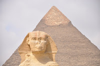
An Interactive Map of the Roman Empire

A few years ago I wrote about a must-bookmark resource from Stanford University for history teachers and students. That resource is called ORBIS and it has been updated since the last time that I wrote about it. ORBIS is Stanford University’s Geospatial Network Model of the Roman Empire. On ORBIS students can calculate the distance and travel times between […]
This Could be a Great Opportunity for a History Teacher

The Library of Congress has a program called Innovator in Residence that provides funding for one person to develop innovative tools that incorporate artifacts housed by the Library of Congress. Over the last few years I’ve featured a couple of tools that were developed through the Innovator in Residence program. Those are Citizen DJ and […]
Resources for Teaching and Learning About Veterans Day

Veterans Day is this Thursday. If you find yourself looking for some quick lessons to review with your students, here’s a small collection for you. ReadWorks ReadWorks is one of my favorite places to go when I need information texts about a holiday to share with students. ReadWorks has a good collection of Veterans Day […]
The United Nations Explained for Kids

A couple of weeks ago I discovered CBC Kids News and I shared a great video that explains what the word indigenous means when referring to people. This afternoon I browsed through CBC Kids News again and found a nice animated video that explains the United Nations to kids. United Nations Explained is a short […]
Tour the Great Wall of China – A New Google Arts & Culture Experience

After Google announced the closure of Google Expeditions earlier this year Google Arts & Culture became the place to go to find much of the virtual imagery that was available in Expeditions. The library of imagery and stories in Google Arts & Culture has steadily grown throughout the year. The latest big addition to that library […]
Influenza Archives – A History Lesson

Monday’s featured artifact on Today’s Document from the National Archives was “Nurse wearing a mask as protection against influenza. September 13, 1918.” As is often the case with items in the daily feed there was a link to additional information about the image. In this case the additional information was a National Archives collection of […]
The Way of a Ship – Historical Math Problems

A couple of weeks ago I picked up an interesting book at my local library. It’s titled The Way of a Ship and it follows the journey of Benjamin Lundy as he sails around Cape Horn in 1885 in one of the last square-rigged commercial sailing boats. The Way of a Ship is full of […]
12 Good Places to Find Historical Images to Spark Inquiry

Historical photographs, paintings, sketches, and maps can inspire all kinds of history questions. That is why for more than a decade I’ve used and recommended images from Today’s Document from the National Archives to prompt classroom discussion as the introduction to U.S. and World History lessons. There are dozens, perhaps hundreds, of other similar galleries […]
How to Use Google Scholar to Learn About Inventions and Inventors

Last week I published a blog post outlining five things that students should know about using Google Scholar. One of those things is the option to search for U.S. Patent Office filings. When you locate a patent filing through Google Scholar you can read the details of the patent application, look at drawings that accompany […]
Primary vs. Secondary Sources

A couple of times this week I have written about using primary sources in history lessons and or research lessons. That has reminded me of a couple of good videos that can help students understand the differences between primary and secondary sources. The Minnesota Historical Society offers a fantastic video on the topic of primary v. […]
World History Commons – Annotated Primary Sources for Students

World History Commons offers a free collection of more than 1700 primary sources covering a wide array of themes and events in world history. The best part is that all of the primary sources in the collection are annotated with helpful notes for students. World History Commons also offers a collection of free teaching guides […]
Five Activities for Teaching and Learning With Primary Sources

As a history teacher one of my favorite yet challenging things to do was introduce my students to primary sources. It’s great because it reveals to them a whole new world of research opportunities. There’s nothing better than a student saying, “wow! Mr. Byrne, look at this!” At the same time learning to read, evaluate, […]
Seven Good Tools for Creating and Publishing Online Timelines

Creating timelines has been a staple in history teachers’ playbooks since the beginning of history. Writing a timeline is a good way for students to chronologically summarize sequences of events and see how the events are connected. When I was a student and when I started teaching timelines were made on large pieces of paper. […]
Three Good Resources for Teaching With Primary Sources

I’m currently developing a new version of my popular online course, Teaching History With Technology (you can see a preview last year’s course here). Part of that process has been revisiting collections of primary sources and some of the tools that I recommend for teaching lessons based on primary sources. Here are three of the many […]
Cronobook – A Map of Historical Photographs

Cronobook is a new-to-me website that features a searchable map of historical photographs. The premise of the site is simple and using it is easy. Just head to the site, search for a location, and click on the small images to see them in full size. A little bit of information including location and […]
Finding Primary Sources in the World Digital Library

The World Digital Library is a resource that I started using back in 2009. At that time it was just a small collection of about 1,200 digitized primary source artifacts from libraries around the world. Today, the World Digital Library hosts more than 19,000 digitized primary source artifacts to view and download. As you’ll see […]
Homeschool History – A Podcast Series for the Family

About eight years ago there was a BBC podcast series called A History of the World in 100 Objects. It was a good series that featured short lessons about objects in The British Museum. New episodes haven’t been added in years, but the series is still available to listen to online. I mention that old […]
A Good Collection of PowerPoint Presentations for AP US History and World History

Tom Richey produces great instructional videos for students taking AP US History, World History, and Government courses. More than 100,000 YouTube subscribers will attest to that. He also publishes many of the PowerPoint presentations that appear in his videos. From his PowerPoint page you can download presentations on US History, European History, or World History. Google Chrome users who […]
My Top 5 Google Tools for Social Studies Teachers and Students

As longtime readers of this blog know, my background is largely in social studies with a smattering of special education and corporate training thrown in for good measure. It’s teaching social studies that will always be my first professional love. That’s why I always get excited when readers send me questions like the one I […]
Langscape – An Interactive Map of Languages

Langscape is an interactive map created at the Maryland Language Science Center. The Langscape interactive map displays more than 6,000 markers representing more than 6,000 languages. Each marker represents the native language of that location. Zoom-in and click on a marker to learn more about the language. When you click on the marker you will […]
The WWII Museum Announces D-Day Electronic Field Trip
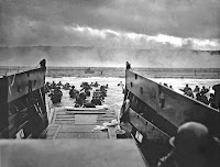
This year is the 75th anniversary of D-Day. This spring the WWII Museum (a must-see for anyone visiting New Orleans) is hosting a virtual field trip all about D-Day. The field trip will take students to the coast of southern England and the invasion sites in Normandy, France. Live Q&A is a part of this […]
800+ Persuasive Maps – And a Tool for Making Your Own

About a week ago Open Culture published an article about Cornell University’s Persuasive Cartography collection. I hadn’t seen that collection before so I went down a rabbit hole looking at map after map for a good 45 minutes. Persuasive maps aren’t maps that you would use to teach a classic geography lesson. That’s because persuasive […]
17 Lessons in Teaching History With Technology

This coming Monday evening (7pm ET) I am hosting Teaching History With Technology on PracticalEdTech.com. This course meets five times (once per week). There are seventeen concepts that are covered in the course. Each concept can be applied to the creation of technology-infused history lessons. The concepts covered in the course are listed below. Using […]
How I Found a Google Earth File of 550+ Ancient Greek Places

Last night on Twitter Wes Fryer asked me if I knew of any Google Earth files that displayed ancient Greek locations. I didn’t have anything within my own bookmarks so I did a quick Google search that I filtered according to file type. I first filtered by file type .KMZ but that didn’t get me […]
Find & Read Old Newspapers Through the Google Newspaper Archive
Yesterday’s blog post about the Chronicling America collection of digitized newspapers prompted Daniel Bassill to ask me about options for newspapers printed after 1963. My suggestion was to try the Google Newspaper Archive. In that archive you will find hundreds of digitized copies of newspapers printed around the world. In the archive you fill find […]
Discover Primary Sources by Browsing the World Digital Library Maps

The World Digital Library hosts more than 19,000 primary documents and images from dozens of libraries around the world. Hosted by the Library of Congress and sponsored in part by the United Nations Educational, Scientific and Cultural Organization, the mission of the World Digital Library is to promote the study and understanding of cultures. The WDL can be searched by date, […]
An Animated Map of the Rise and Fall of Communism

The Spread of Communism is an animated map that shows the rise and fall of communism from 1917 through 2017. When you visit the map you can press the play button in the lower, right corner to play the animation. When it plays the animation highlights each country according to the year in which a […]
Echoes of the Great War – Online WWI Exhibition

Echoes of the Great War is a fantastic collection of videos, audio recordings, and pictures about WWI. This online exhibition created by the Library of Congress. Echoes of the Great War is arranged thematically. Those four themes are Arguing Over War, Over Here, Over There, and World Overturned. Within each of those themes you will […]
Ancient Rome 101 and Life as a Roman Teenager

National Geographic has a great series of YouTube videos called National Geographic 101. The most recent addition to that series is Ancient Rome 101. The video provides an excellent introduction to the origin, rise, and fall of the Roman Empire. The length and substance of the video makes it an ideal candidate for inclusion in […]
Virtual Tours of Ancient and Modern Greece

Google Earth, Google Maps, and Google Expeditions all provide good ways for students to see the sites of Greece. But if you would like your students to find a bit more detail about those sites, the National and Kapodistrian University of Athens has an excellent resource for you. The National and Kapodistrian University of Athens […]
Eight Lessons in Teaching History With Technology

A couple of month ago I launched an on-demand version of my popular Teaching History With Technology course. So far more than 50 people have completed the course. The question that almost everyone asks before they enroll in the course is, “what’s covered in the course?” That’s a fair question to ask so I published […]
Ancient Egypt 101 – A Six Minute Primer
Ancient Egypt 101 is a new video produced by National Geographic. The video doesn’t reveal any new information or go into any great detail. What it does provide is a concise overview of the history of ancient Egypt and how some aspects of ancient Egyptian culture are still present today. Applications for Education One of […]
A Multimedia Timeline of WWII in Europe
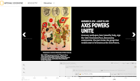
Last week I shared National Geographic’s excellent multimedia timeline of the Pacific Theater of WWII. National Geographic offers a similar timeline of the European Theater. While the title of the timeline is World War II in Europe, it does include include events that happened in Africa and some events in the United States. The timeline […]
8 Good Resources for Learning About Pearl Harbor

Tomorrow is the 76th anniversary of the Japanese attack on Pearl Harbor. Of course, that wasn’t the first military action of the Japanese during WWII. It’s just the event that finally got the U.S. to declare war. The 1941 Project is an interactive map of Pearl Harbor. The map features the stories of survivors of the […]
A Multimedia Timeline of WWII in the Pacific
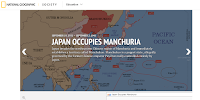
As any good student of history can tell you, the Pacific theater of World War II was just as complicated as the European theater. National Geographic has a multimedia timeline that can help students understand the sequence and significance of events in the Pacific theater. World War II in the Pacific is a timeline that […]
Teaching History With Technology – On-demand PD
Teaching History With Technology is my most popular Practical Ed Tech course after Getting Going With G Suite. In the last year more than 100 people participated in the course. Previously, I have only offered it as a live course that required participants to join weekly webinars. This fall I’m going to offer it in […]
Historical Patterns Animated
Some of my favorite social studies lesson plans include having students use maps to analyze data and identify patterns in history. Over the years I’ve done this with paper maps and digital maps. Mapping History, produced by the University of Oregon, features lots of animated maps illustrating problems, patterns, and events throughout history. Mapping History […]
How to Create a Simple Timeline-based Game

ClassTools.net has many great online game templates for history teachers to use. Play Your Dates Right is one of the templates that I like to use to create a game that is focused on helping students recall the sequence of historical events. In the video embedded below I demonstrate how to create a simple timeline-based […]
Play Your Dates Right – A Fun History Game

Play Your Dates Right is another great game template developed by Russel Tarr at ClassTools.net. The concept of Play Your Dates Right is that students have to pick the correct sequence of three historical events. The event in the middle of the game template is always the event that actually did come second. Students have […]
20th Century World History Declassified
The Wilson Center Digital Archive offers many collections of declassified historical documents. The documents contain memos and transcripts of communications between diplomats and country leaders. The collections are arranged into topics and themes. You’ll find collections of documents related to the construction of the Berlin Wall, the origins of the Cold War, Sino-Soviet relations, and diplomatic efforts […]
417 History and Civics Lessons In One Place
On Friday I featured Tom Richey’s YouTube channel which is full of great content for Advanced Placement U.S. and European History students. Today, I want to point out or remind you about the excellent videos that Keith Hughes produces. Keith has at least 417 video lessons about a wide range of topics in U.S. and […]
View and Print in 3D More Than 200 Objects from The British Museum
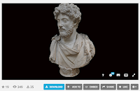
The British Museum collection on Sketchfab contains 252 3D models of artifacts in The British Museum’s collections. You can view these models in 3D in your web browser or in a virtual reality viewer. (To view the models in your browser your browser needs to support WebGL, you can test your browser here). If you […]
How to Find Old Maps Online

In yesterday’s Practical Ed Tech Live episode I answered a question about where to find old maps to layer in Google Earth. One of the resources that I suggested was Old Maps Online. Old Maps Online is a map that you can browse and search to find historical maps to view online, to download, and […]
Nixon’s Visit to China – Documents and Video
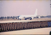
Last week the National Archives Today’s Document feed featured two artifacts from President Nixon’s landmark visit to China in 1972. The first document was actually a photography of Air Force One arriving in China. The second document was the menu from one of the dinners in Peking. Looking at these documents reminded me of some […]
Take a Virtual Tour of Petra In Google Cardboard or In Street View

Last year Google added a virtual tour of Petra to its collection of landmarks that you can see in-depth in Google Maps Street View. This week that tour was updated for viewing in Google Cardboard VR headsets. Much of the imagery used in the tour was captured by a Street View Trekker camera. Take a […]
15 Tools for Teaching History With Technology – Best of 2016
As I usually do during this week, I’m taking some time off to relax, ski, and work on some long-term projects for the next year. This week I will be re-publishing the most popular posts of 2016. One of the things that teachers often ask me for is a set of tools to get them […]
World Population History – An Interactive Map and Timeline
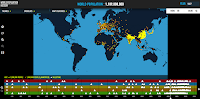
Last night on the Practical Ed Tech Facebook page I shared a post from Randy Krum that included a visualization of U.S. population growth. Watching that visualization led me to a related visualization about world population growth. World Population History is an interactive map and timeline of the world’s population growth from 1 C.E. to […]
Resources for Teaching About Veterans Day
This coming Friday is Veterans Day and schools across the US will be closed. Try one or more of the following resources to help students understand the origins and meaning of Veterans Day. Bet You Didn’t Know: Veterans Day. The video explains the origins of the holiday and why its date of celebration has twice […]
A Thorough Video Overview of the French Revolution
In my previous post I shared the new TED-Ed lesson about the French Revolution. That video lesson is fine as an introduction in a middle school classroom. For a much more in-depth video lesson on the French Revolution students should turn to Tom Richey. Tom offers a thirteen part series on the French Revolution. The […]
A Short Introduction to the French Revolution
What Caused the French Revolution? is the title and topic of a new TED-Ed lesson. Like most TED-Ed lessons, the video provides a brief overview of the key points you’d find in a typical middle school or high school history textbook. The lesson introduces students to the three Estates of pre-revolution France, the National Assembly, […]
NATO on the Map – An Interactive Overview of NATO
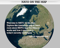
NATO on the Map is an interactive map of information about about NATO. The map, viewable in 2D and 3D, displays information about NATO member countries, partner countries, NATO actions, and NATO security challenges and responses. When you visit NATO on the Map you can choose to display information from five categories. Selecting a category […]
Interactive Maps of Travel Through the Roman Empire
If you teach any lessons about the Roman Empire, take a look at ORBIS from Stanford University. ORBIS is Stanford University’s Geospatial Network Model of the Roman Empire. On ORBIS students can calculate the distance and travel times between 751 settlements in the Roman Empire. The calculations happen according to the modes of travel that […]
5 Online Activities for Teaching With Primary Sources
As a history teacher one of my favorite yet challenging things to do was introduce my students to primary sources. It’s great because it reveals to them a whole new world of research opportunities. There’s nothing better than a student saying, “wow! Mr. Byrne, look at this!” At the same time learning to read, evaluate, […]
PBS World Explorers – The Lives & Journeys of Famous Explorers

PBS World Explorers is a new collection of videos from PBS Learning Media. The PBS World Explorers collection includes sixteen short videos about famous explorers throughout history. Some of the explorers featured in PBS World Explorers include Leif Ericson, John Cabot, and Zheng He. You’ll also find the usual suspects in the collection including Marco […]
10 Good Video Sources for Social Studies Teachers and Students
Last week I shared a list of good sources for mathematics videos. That post was one of the most popular posts of the month despite being published during a school vacation week. Seeing the results of that list has prompted me to share lists for other subject areas. Here is my list of good video […]
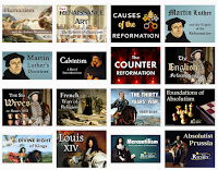
Dozens of Great PowerPoints for AP History Students & Teachers
As I do every year, I am taking this week to relax, recharge, and ski with friends. While I’m away I will be re-running the most popular posts of the year. This was one of the most popular posts in November, 2015. As I’ve mentioned in the past, Tom Richey produces great instructional videos for […]