1,001 Novels Mapped
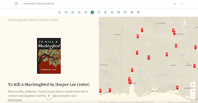
I’m taking the week off to do a bunch of fun things with my kids. While I’m away the most popular posts of the year so far will reappear. 1,001 Novels: A Library of America is an ESRI story map developed by Susan Straight. The story map features short reviews of 1,000 American novels. Each […]
A Good Tool for Mapping Census Data
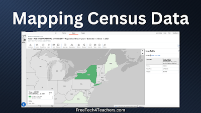
Earlier today I was looking for a dataset that I could use in a new data visualization tool that I’m testing out. That quest took to me the website of the U.S. Census Bureau. It was there that I went down a rabbit hole of looking at data. Eventually, I stumbled into a mapping tool […]
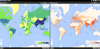
A Good Way for Students to Visually Compare the Sizes of Countries and States
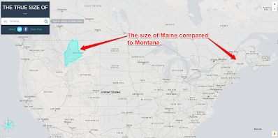
My students here in Maine always think of our state as being a big place and it is big in relation to the rest of New England. Compared to our friends in the west, Maine is a small place. Similarly, they sometimes have trouble understanding the size of the lower 48 states compared to Canada. […]
A World of Musical Explorers
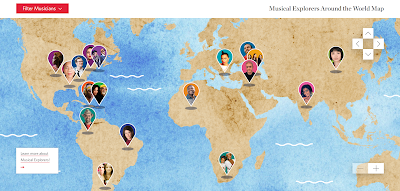
I wrote about this neat resource a couple of years ago. A recent post on the Maps Mania blog prompted me to revisit it. Carnegie Hall hosts some excellent online instructional resources for music teachers. One of those resources is called Musical Explorers Around the World. Musical Explorers Around the World is an interactive map […]
How to Create Custom Route Maps in Google My Maps
In a few weeks I’m participating in a global bicycling challenge that asks participants to complete 100 miles of biking on one Saturday. I’m going to do it with a couple of my friends. In preparation for that day I’ve been mapping out a variety of routes that we could take. We’ll decide before we […]
Five Good Collections of Historic Maps for Classroom Use

Last week I wrote a blog post featuring the newly published historic map collection hosted by the Internet Archive. That collection, the David Rumsey Historical Map Collection, is the latest of the historic map collections that I’ve featured on this blog over the last fifteen years. Here are some others that I’ve featured and used […]
More Than 100,000 Historic Maps for Classroom Use
Credit: David Rumsey Map Collection, David Rumsey Map Center, Stanford Libraries. Source 1. Source 2. In this week’s Practical Ed Tech Newsletter I mentioned that digital mapping tools is one of the areas of educational technology that I’m still passionate about after sixteen years and 17,000 blog posts. And making comparisons through the use of […]
Projection Wizard – See How Maps Distort the World

Projection Wizard is an interesting tool developed by Bojan Šavrič at Oregon State University. The purpose of Projection Wizard is to help cartographers select the best map projections for their projects. To use the Projection Wizard select a distortion property from a menu appearing to the left of the map. Then use the highlighting tool […]
Maps and Videos About Where Thanksgiving Foods Come From

Where Does Your Thanksgiving Dinner Come From? is an interactive storymap that I’ve shared in the past and still find interesting. The map displays where eight popular Thanksgiving foods are grown and harvested in the United States. The storymap includes a map for each ingredient. Each map shows the locations of commercial producers. Fun facts are […]
GeoQuiz History Edition – A Fun and Challenging Geography Game

The start of Geography Awareness Week is nine days away. It’s probably my favorite academically-themed week of the year. (Yes, that’s my social studies teacher background coming through). Over the next week or so I’ll be sharing a bunch of great resources for teaching and learning about geography. To start things off I have a […]
How to Create a Digital Map Collection in Wakelet

Wakelet is a free, collaborative bookmarking and file organization tool that puts things into a nice visual display. So when a former colleague emailed me a couple of days ago to ask for help creating a collection of digital maps Wakelet was one of the first tools to come to mind (Padlet was the other). […]
DIY Maps of Bird Migration Patterns

Over the last handful of years I’ve become more and more fascinated with birds. I think that’s due in part to my daughters’ enjoyment of watching the many interesting birds that come to the feeders around our house. We’ve even taken to naming some of the birds that visit the feeders. For example, Hans is […]
NearbyWiki – A Mapped Display of Wikipedia

NearbyWiki is a new website that displays Wikipedia entries on an interactive map. The purpose of NearbyWiki is for visitors to learn about buildings, statues, and parks by clicking through a map. For example, a search for Boston on NearbyWiki will reveal more than 500 markers on the map in and around Boston. You can […]
Ten Fun Things for Students to Map

Last week I published a video about how to record a Google Earth tour in your web browser. That’s just one of many tools that students can use to create multimedia maps. A few other options include using Scribble Maps, Padlet maps, and Google’s My Maps tool. Creating a map with one of these tools […]
The Geography of Baseball Fans

The Major League Baseball season started yesterday. This morning while I was flipping through some highlights of yesterday’s games, I was reminded of a neat map that I cam across a few years ago. SeatGeek’s interactive map titled Where do MLB Fans Live? is an interactive map that shows which teams are the most popular teams […]
Create Your Own USGS Maps

Earlier this year I highlighted the galleries of free to use and re-use media that the USGS hosts. Earlier this week I was back on the USGS site looking in those galleries when I noticed something new to me. That something is the USGS National Map Viewer. Don’t the name fool you, the USGS National […]
Map Puzzle – Test Your Knowledge of World Geography
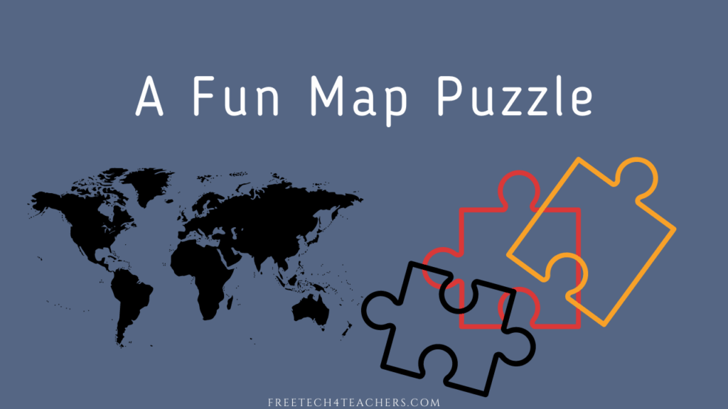
MapPuzzle is a simple online geography game that I recently learned about through the Maps Mania blog. The game is based on the premise of political boundaries being the lines in a jigsaw puzzle. You have to drag the countries, states, or provinces into their proper places on the map. MapPuzzle offers a dozen puzzles […]
4,000+ Maps of Military Battles and Campaigns
The Library of Congress housed hundreds of thousands of maps covering a huge array of topics from maps used by fire insurance companies to population density to maps of military battles and campaigns. The LOC’s collection of maps of military battles and campaigns contains more than 4,000 maps that are free to view, download, and […]
Nine Interactive Maps Depicting the History of the United States

American Panorama is a great resource from the University of Richmond that I first reviewed six years ago. Since then it has expanded from four interactive maps to nine interactive maps of United States history. American Panorama aims to be an atlas of United States History. Currently, American Panorama features nine interactive maps representing elements and […]
Finding a Geographic Opposite

One evening last week my daughters were playing with the globe pillow that is featured in this blog post. They started asking questions about what each place is called and where it is relative to where we live. Answering their questions reminded me of the concept of an earth sandwich. The idea of an earth […]
Mapping Where Food Comes From

Where Does Your Thanksgiving Dinner Come From? is an interactive storymap that I’ve shared in the past and still find to be a neat resource. The map displays where eight popular Thanksgiving foods are grown and harvested in the United States. The storymap includes a map for each ingredient. Each map shows the locations of commercial […]
My Big List of Activities and Resources for Geography Awareness Week
This week is Geography Awareness Week. It’s one of my favorite weeks of the year! Every year at this time I publish an updated list of some of my favorite games, activities, tools, and lessons to promote geography awareness. Here’s my updated list for 2021. The first place to start a search for geography awareness […]
NatGeo MapMaker – Create, Share, and Print Custom Maps

National Geographic MapMaker is a nice mapping tool that I’ve been using and recommending for years. It was recently updated with an improved user interface, additional data sets, and more annotation tools. With NatGeo MapMaker you can create custom maps to display datasets, to compare datasets, to illustrate collerelations, and to illustrate points. National Geographic […]
The Living Atlas of the World

The ArcGIS Living Atlas of the World is a collection of thousands of online, interactive maps representing all kinds of data. The contents of the collection range from relatively simple displays of historical map imagery to complex, displays of data updated nearly live. For example, this map displays active hurricanes, cyclones, and typhoons. Another good […]
How to Create Custom Coloring Maps

There are plenty of places on the Internet to find free outline maps of states, provinces, countries, and regions of the world. Finding blank outline maps of cities, small towns, or neighborhoods is a little harder to do. If you’re looking for a blank map of a city, town, or neighborhood for your students to […]
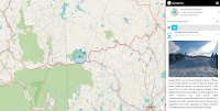
Great Reads from Great Places – An Interactive Map from the Library of Congress

Great Reads from Great Places is an interactive map produced by the Library of Congress for the National Book Festival. The purpose of the map is twofold. First, to help visitors find National Book Festival-related events in their states. Second, to help visitors find books that are connected to their states. Those connections could be […]
Exploring Newspapers Through Maps

When I included current events as a regular part of my social studies classes I would always show a map of where a story takes place. The following websites can provide students with a geographic connection to current and historical news stories. Newspaper Map is a neat tool for locating and reading newspapers from locations all […]
An Interactive Map of Historical Sites in Every U.S. State

The Traveling Salesman Problem is a website developed by William Cook at the University of Waterloo. The site features interactive maps that chart the short distance between a series of places. One of those maps is of all of the places in the United States National Register of Historic Places, all 49,603 of them.You can […]
How to Quickly Create Animated Maps

A couple of weeks ago I wrote about new mapping tool called Mult Dev. It’s a free tool that lets you quickly create animated maps. In the time since I wrote about Mult Dev a couple of updates were made to it. The most notable of those being that you now need to sign into […]
A Math and Map Challenge

This evening while recording Two Ed Tech Guys Take Questions & Share Cool Stuff I was reminded of a neat math and map challenge activity from Mathigon. Here’s what I wrote about it last year. Mathigon’s map coloring challenge is to use as few colors as possible to color in all 50 U.S. states without the […]
Mult.dev – A New Way to Quickly Make an Animated Map

Mult.dev is a new mapping tool that I recently learned about through Maps Mania. Mult.dev does just one thing but does it very well. That thing is create animated maps illustrating the connections and travel distance between two or more places. To create an animated map on Mult.dev you do not need an account. You […]
Three Good Options for Drawing on Digital Maps

Creating layers and tours in Google Earth and Google My Maps can be a great way for students to assemble collections of geolocated information to summarize research, create a book tour, or even develop safe walking and biking routes. But sometimes you just need to quickly draw or pin things to a digital map. In […]
Musical Explorers World Map

Carnegie Hall hosts some excellent online instructional resources for music teachers. One of those resources is called Musical Explorers Around the World. Musical Explorers Around the World is an interactive map designed to introduce students to musicians, instruments, and music from around the world. To use Musical Explorers Around the World students simply have to […]
What is a Map? – And a New Crash Course in Geography

For as long as I can remember I’ve enjoyed looking at maps. Whether it’s a standard Mercator projection printed on paper or a digital map, looking at maps sparks curiosity in my brain. I’m certain that’s why I always enjoyed teaching geography and why I spend so much time today teaching others how to use […]
Virtually Explore America’s Quietest Roads

America’s Quietest Roads is an interactive map created by a road traffic analytics company called Geotab. The map features the quietest state or federal highway in all fifty states. They define quietest as having the least average number of vehicles traveling the road throughout the year 2015. It’s important to point out to students that […]
A New Collection of 17,000+ Historical Maps and Images

Flickr’s The Commons is a great place to find all kinds of interesting historical photographs from museums and libraries all over the world. Recently, The British Library added a new collection of maps to Flickr’s The Commons. The new collection is called the King’s Topographical Collection and it contains more than 17,000 historical maps and images […]
Map Lessons from Mathigon

Last spring I wrote about Mathigon’s Map Coloring Challenge. That’s not the only map-based math lesson available from Mathigon. Mathigon’s lesson on spheres, cones, and cylinders incorporates map projections. In Surface Area of a Sphere Mathigon includes an interactive diagram that illustrates the problem that cartographers have when trying to create maps of the world. […]
Cronobook – A Map of Historical Photographs

Cronobook is a new-to-me website that features a searchable map of historical photographs. The premise of the site is simple and using it is easy. Just head to the site, search for a location, and click on the small images to see them in full size. A little bit of information including location and […]
Three Ways to Explore the News Through Maps

One of the things that I liked about the old version of CNN Student News is that it almost always included a map to show students where a story is taking place in the world. I tried to do the same whenever I taught current events by showing students a map of where a story […]
A Challenging Battles and Heritage Map Game

Geoquiz History Edition is a fun and challenging history game for history buffs. The game works like similar geography games in which you’re given the name of a place and have to place a marker on a blank outline map as close as possible to the actual location. In Geoquiz History Edition you’re given the […]
Scribble Maps – Create Multimedia Maps – No Account Required

Earlier this week I presented a webinar about using Google Maps and Earth for more than just social studies lessons. A follow-up email that I received came from a teacher who wanted to know if there was a way for her students to create multimedia maps without needing to sign into a Google account. My […]
How to Create Labeling Activities With Google Drawings and Classroom

Last week I hosted a webinar for a group that I’m working this summer. One part of that webinar included making online activities for students. I included some of the typical things like Kahoot and Wizer but I also included a demonstration on how to use Google Drawings to make online labeling activities. In the […]
Teamimg – Collaborate to Make Interactive Images

Teamimg is a free tool that is a bit like Thinglink and Classtools’ Image Annotator without the hyperlinks. Teamimg lets you upload an image and share it. Once uploaded you can click on the image to write comments and reply to the comments that other people have written. The comment threads can be expanded or collapsed […]
Gribrouillon – Freehand Drawing on Online Maps

For many years I’ve recommended Scribble Maps as a no-account-required alternative to Google’s My Maps. Scribble Maps lets create freehand drawings on digital maps. Today, thanks to Maps Mania, I learned about another tool for making freehand drawings on digital maps. That tool is called Gribroullion. Using Gribroullion is a straight-forward process. Simply go to […]
Ten Fun and Challenging Geography Games for Students of All Ages

Over the years I’ve tried dozens of online geography games for students of all ages. Many have come and gone over the years but the following geography games are still going strong. WikiWhere is a neat map-based trivia game. The goal of the game is to identify cities based on their descriptions. The descriptions come from […]
How to Create Interactive Images With Classtools

A couple of days ago I wrote about a new tool from Classtools called Image Annotator. It does exactly what it says on the tin. I made the following short video to demonstrate how easy it is to use the Classtools Image Annotator. In the video I demonstrate annotating an image of a map, but […]
How to Create a Multimedia Map on Padlet

Last week I shared the news that Padlet now includes multimedia map creation options. Like all other Padlet layouts, the map option includes the capability to collaborate. The maps that you create on Padlet can have placemarkers that include pictures, videos, links, text, and audio files. You can even record audio and video within the […]
More Than 30,000 Historical Maps for Student Projects

This morning I was looking for a historical map of Mount Vernon to overlay onto Google Earth imagery. (I’m publishing a video about that later this week). I was able to find exactly what I was looking for in the historical map collection available through the Library of Congress. LOC’s online historical map collection has nearly […]
Camera and Locomotive – A Mapped Story About the Transcontinental Railroad
Camera and Locomotive is the title of a fantastic mapped story published by the Library of Congress. Camera and Locomotive tells the story of the building of the Transcontinental Railroad and the development of photography in the United States. As you scroll through the story you will find interactive maps that are loaded with photographs […]
Lee’s Map of Gettysburg – And Tools for Making It Interactive

Today’s featured document featured by the National Archives is a copy of General Robert E. Lee’s map of the Battle of Gettysburg. If you download a copy of the map (which you can do as it is in the public domain) and then zoom-in on it, you will be able to see the notations about […]
Where Do Baseball Fans Live? – Interactive Map

Despite the couple of games that the Mariners and Athletics played in Japan last week, Major League Baseball is calling today the opening day of the season. As a lifelong fan of the defending World Series champions, the Boston Red Sox, I am excited for the start of the season. Where do Red Sox fans […]
The Story of the United States Told in 141 Interactive Maps
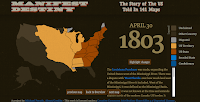
Manifest Destiny – The Story of The U.S. Told in 141 Maps is a great website developed by Michael Porath. As you probably guessed from the title of this blog post, the site features 141 interactive maps chronicling the expansion of the United States from March 1789 to August 1959. When you click on any of the […]
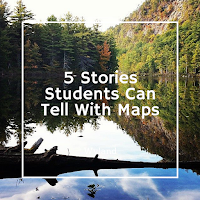
5 Ways to Tell Stories With Maps
Maps can be great tools for supporting nonfiction and fiction stories. Being able to see the greater context of a location can go a long way toward helping students see the complete overview of a story. This can be helpful for learning about historical events, for supporting biographies, or for seeing the settings of fiction […]
A Great Example of Sharing Stories Through Google’s My Maps

Kevin Hodgson’s blog has been one of my daily reads for the better part of the last ten years. Kevin is a sixth grade teacher and masterful storyteller. Over the years I have learned a lot from reading his blog. Earlier this week Kevin published a blog post titled #WriteOut:Mapping the Immigrant Experience at the […]
Turn CSV Files Into Heat Maps

Heat Map Tool is a tool for easily creating heat maps or incident maps from a CSV file. To create a heat map all you need to do is upload a CSV file then specify your desired display attributes like scale, colors, and opacity. You can edit the display attributes of your map whenever you like. If […]
Three Tools for Combining Maps With Timelines

Creating timelines whose events are directly connected to a map display is a good way for students to see correlations between locations and events. Here are three tools that students can use to create mapped timeline stories. StoryMap JS comes from the same people that offer Timeline JS. On StoryMap JS you can create mapped stories. […]
Google Tour Builder
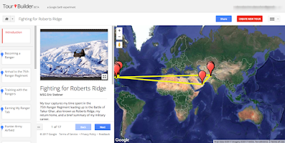
Google Tour Builder was originally created for veterans as a tool to record and preserve their experiences and memories in the military and share them with friends and family. Google made Tour Builder available to everyone because they know everyone has a story to tell. While Tour Builder isn’t as popular as Google MyMaps, it has some features […]
27 Ideas for Teaching With & About Topographic Maps – From the Archive

Due to an injury and some pressing personal matters requiring my attention, posts for the rest of the week will be favorites from the archive. The USGS offers free topographic maps for most of the United States. The maps can be downloaded as PDFs through the USGS store. The maps can be used in the […]
Storymap JS – Tell Stories With Maps

The New York Times has a new feature called Harriet Tubman’s Path to Freedom. The feature is a presented in scrolling map format. The map is combined with a timeline format that shows the sequence of and locations of significant moments of Tubman’s work in freeing herself and helping other slaves escape. Harriet Tubman’s Path […]
A Map of Languages
Locallingual is an interactive map of languages and dialects around the world. You can click on the map to read the language(s) spoken within a country, province, state, or city. You can then click on the listed language(s) to hear words and phrases spoken by people who live in that area. It’s a neat way […]
Explore Maps of Historical Sites in Every U.S. State
The Traveling Salesman Problem is a website developed by William Cook at the University of Waterloo. The site features interactive maps that chart the short distance between a series of places. One of those maps is of all of the places in the United States National Register of Historic Places, all 49,603 of them.You can […]
5 Types of Stories Students Can Tell With Digital Maps
When most teachers hear or read about Google Maps, Google Earth, ESRI, and other digital mapping tools they tend to think about social studies topics. While digital mapping tools are perfectly suited to social studies lessons, they can also be used in other subject areas including math, language arts, and science. Here are five types […]
27 Ideas for Teaching With & About Topographic Maps

The USGS offers free topographic maps for most of the United States. The maps can be downloaded as PDFs through the USGS store. The maps can be used in the 27 suggested topographic maps lessons found in the USGS education site. All of the lessons are rated by grade level and time required for completing […]
Free Printable Maps from the USGS and National Geographic
The United States Geological Survey creates topographical maps of the United States. The USGS maps can be downloaded for free from the USGS website. The USGS website can be a little tricky to use. Another option is to use National Geographic’s USGS map portal to find, download, and print maps. On that site you can […]
PAT – Free, Open Source, Portable Atlas

PAT is a free collection of maps developed by Ian Macky. The collection includes maps of every country in the world.The collection also includes maps of U.S. states, maps of Canadian provinces, Australian states, and regional maps. You can download any and all of these detailed maps for free. Applications for Education PAT is an excellent resource for geography and […]
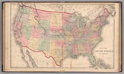
Three Ways for Students to Compare the Sizes of Countries and States
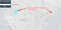
My students here in Maine always think of our state as being a big place and it is relative to the rest of New England. Compared to our friends in the west, Maine is a small place. Similarly, they sometimes have trouble understanding the size of the lower 48 states compared to Canada. The following […]
Geopedia – A Map & Wikipedia Mashup
Geopedia is a nice combination of a map and Wikipedia entries. Search for a location on the Geopedia map and you will be shown a bunch of map placemarks around that location. Click on any of the displayed placmarks and you will see a corresponding image and Wikipedia entry. To change locations you can either […]
An Interactive Cartogram of News
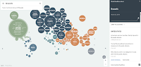
Unfiltered News is a new site that uses an interactive cartogram to help you find trending news stories from around the world. To find stories through Unfiltered News simply open the website and click on a topic listed within one of the circles on the map. Once you’ve made a selection a list of stories […]
Mapping the Emerald Isle – An Interactive Map of Surnames in Ireland

Happy St. Patrick’s Day! Today, is a perfect day to share a neat interactive story map produced by ESRI. Mapping the Emerald Isle: a geo-genealogy of Irish surnames is an interactive map depicting the distribution of Irish surnames across Ireland according to the 1890 census. To use the same simply select a name from a […]
Students Can Compare Maps Side-by-Side in GE Teach
GE Teach is a great map tool that I last featured about 18 months ago. GE Teach is developed and maintained by a high school teacher in Texas named Josh Williams. We had the chance to meet at TCEA this week and chat about GE Teach. GE Teach has gone through a bunch of iterations […]